Projects
Projects
Projects

Besis Tourism City Masterplan, Besis / Libya, 2010
 |  |
|---|---|
 |  |
 |
Besis Turizm Şehri Masterplanı, Besis
Planlamanın temel amacı, yılın her günü ve günün her saatinde canlı bir turizm kenti kurmaktır. Önerilen gelişme, yılın her mevsiminde turist ağırlayacak şekilde farklı bir turizm konseptine sahiptir. Deniz turizmi, Kongre turizmi, Spor turizmi, Eğlence ve turizm.
Bu çeşitli turizm konseptleri arasında, farklı ölçek ve topolojiye sahip çeşitli turizm konseptleri öne sürülmüştür.
Master plan, bir merkez ve üç alt merkezden oluşan dört karakter alanı olarak ayrılmıştır. Her merkez, farklı yapı ve peyzaj karakteri konseptilerine göre dizayn edilmiştir.
-
Bu imarın kalbinde, otel ve kongre merkezi vardır. Ana ana merkez, büyük bir mesire arazılığıyla sahil şeridine açılır. Sokak sahile dik olarak düzenlenmiştir. Ana merkezi çevreleyen konut tipolojisine ayrı ayrı hizmet sunulmaktadır.
-
Sahanın doğusunda, eğlence parkı ve aqua park gibi eğlence imkanları içeren bir alt merkez vardır. Burada, deniz kıyısında bulunan evlerde oluşan mahalle sahil kıyısına ve aqua parka paralel olarak yapılandırılmıştır.
-
Imarın güneyinde, alt merkezde, açık sahalar, golf sahası ve sporcular için konaklama imkanı gibi hizmetleri bulunmaktadır.
-
Kuzeyde ise, ada, plaj ve eğlence alanları ile çevrili bir otel kompleksi olan bir alt merkez olarak dizayn edilmiştir.
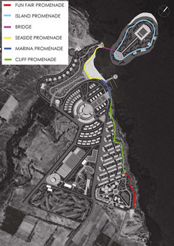
Mesire, mahalle sakinlerinin, eğlenceli sakin yürüyüşler yapabilecekleri şekilde deniz kenarına erişebilmelerine olanak sahlayan sahil şeridi boyunca uzanmaktadır. Ayrıca, farklı özellikleri ile, mesire, merkezleri ve konut birimlerini birbirine bağlayan sürekli bir rekreasyon güzergahı oluşturur.
İmar, yapılı çevreye denizden rüzgar ulaşmasını sağlayacak şekilde deniz kıyısına dik olarak düzenlenmiştir.
Bu, ayrıca, mahalle sakinlerinin deniz manzarasından yararlanabilmelerini de sağlar.
Merkez ve tüm alt merkezler arasındaki mesafe, ana merkeze eşit uzaklıktadır.
Bu mesafe, ortalama olarak ana merkezden, alt merkeze 6-8 dakikalık bir yürüme mesafesidir.
Mesire boyunca yaşanan deneyim insanları bu mesafeyi yürümek için teşvik eder.
Sirkülasyon Ağı
Araç sokak düzeni, tüm bir yerleşime hizmet ve acil durum erişimi sağlamanın yanı sıra, mesire ile kesişmez ve böylece yay hareketine özen gösterir.
Proje künye
Masterplan: R.Güneş Gökçek
Mimari ofis: YPM
Proje ekibi: Evrim Özlem Kale, Bora Yıldırım, Altuğ Gönençen, Erkan Erdoğan
Proje tarihi: 2010
Arsa alanı: 620.000 m2
Besis Tourism City Masterplan, Besis
Main aim of the planning is to establish a vivid tourism city for every day of the year and for every hour per day. Proposed development is equipped with different tourism concept to house tourist in every season of a year. (Sea tourism, Congress tourism, Sport tourism, Entertainment tourism).
Between these various tourism concepts accommodation of different scale and typology is introduced.
Master plan is zoned in four character areas of a center and three sub-center. Each center is designed with different concepts of building and landscape character.
-
The hearth of the development houses hotel and congress center. This main center opens to the shoreline through a grand promenade. The street patern is organised perpendicular to the seashore. Residential typology surrounding the main center is serviced aparts.
-
To the east of the site is the sub-center containing entertainment facilities such as fun fair and aquapark. here, the sea housing neighborhood is structured parallel to the shoreline and aquapark
-
In the south of the development sub-center contains sports services such as outdoor pitches, golf course. and accommodation for sportsmen and women.
-
In the north the island is designed as a sub-center with a hotel complex surrounded by beaches and recreational areas.
The promenade runs along the shoreline allowing the residents to access the full length of the waterfront for recreational leisurely walks. moreover with its different characteristics, promenade creates a continuous recreational route linking the centers and residential units.
Development is organised perpendicular to the seashore in order to let the wind from the sea in to the built environment.
this also enables residents to take visual advantage of the sea-scape.
Distance between centers
All sub-centers are spaced in equal distace to the main center.
It takes an average 6-8 minute walk from the main center to the sub-centers.
The experience along the promenade encourages people to walk this distance.
Circulation Network
vehicular street layout not only enables service and emergency acces to all over the settlement but also pays attention to the pedestrain movement by not intersecting with the promenade.
Project facts
Masterplan: R.Güneş Gökçek
Architectural office: YPM
Project team: Evrim Özlem Kale, Bora Yıldırım, Altuğ Gönençen, Erkan Erdoğan
Project date: 2010
Land area: 620.000 m2